Home
Welcome
Dr. Yu is currently an Assistant Professor in the School of Geography at Nanjing Normal University. His research primarily focuses on 3D GIS, Virtual Geographic Environments, 3D City Modeling, and Geographic Information Services. His work specifically addresses challenges related to geographic modeling and simulation in the context of 3D GIS.
Dr. Yu has studied at renowned institutions such as the School of Remote Sensing Information Engineering at Wuhan University, the Urban Analysis Lab at National University of Singapore. He has published numerous papers in journals, including ISPRS P&RS, IJGIS, JAG, and NHESS, and has been invited to deliver lectures on 3D GIS, geographic modeling, and virtual geographic environments. He maintains strong collaborative relationships with several governmental organizations and leading industry enterprises. As a key researcher, he contributed to development the development of the Open Geospatial Engine, a cloud-native geospatial analysis platform. Additionally, he contributed to the development of the OGC TrainingDML specification and has participated in the formulation of several National Standards of China. Currently, he is a member of the OpenGMS team.
News
- Our paper was selected for the 2024 Most Publicly Recognized Article Award of Geo-spatial Information Science
- Joined Nanjing Normal University as an Assistant Professor
- Successfully defended my PhD thesis titled Lightweight Generation and Service Methods for Photo-Realistic 3D Building Models
- Received scholarship from China Scholarship Council to visit NUS UAL
 ->
->

- Top Prize of Science and Technology Progress in Surveying and Mapping, Granted by Chinese Society for Geodesy, Photogrammetry and Cartography
- Selected for the 24th Wang Zhi Zhuo Innovation Talent Award
- Selected for the Academic Innovation Award of Wuhan University
 Older news…
Featured Publications
We present RooFormer, an end-to-end deep learning framework for reconstructing high-fidelity 3D roof models from aerial imagery. The method integrates a MaskFormer branch for feature extraction and a novel MeshFormer branch that predicts detailed roof meshes with a local self-attention mechanism and a geometry-aware loss. RooFormer outperforms existing methods in reconstruction accuracy, and its generalization ability across diverse urban regions.
Dayu Yu, Fan Ye, Peng Yue, Min Chen, Filip BiljeckiISPRS Journal of Photogrammetry and Remote Sensing, 227: 745–758, 2025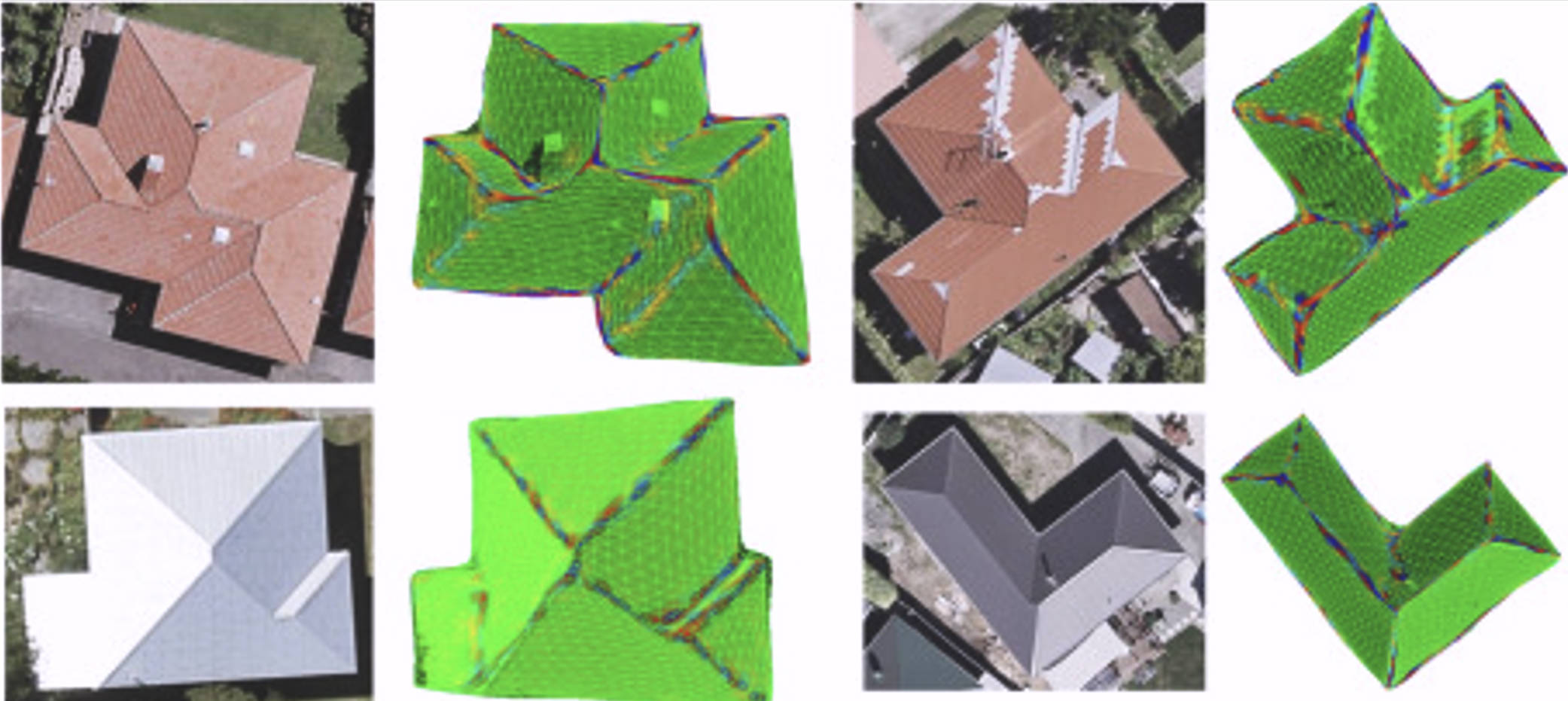
We developed a generic conceptual model suitable for component-level management of diverse 3D spatial data in SDIs and discussed the design rationales and key considerations underlying the model.
Dayu Yu, Peng Yue, Binwen Wu, Filip Biljecki, Min Chen, Luancheng Lu International Journal of Geographical Information Science, 39(4): 847-871, 2025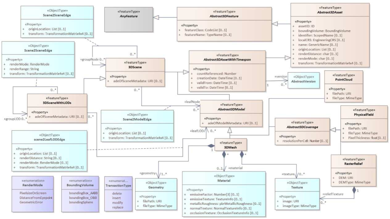
We prpoased a novel bidirectionally greedy framework to extract fine-grained 3D building models from photo-realistic 3D meshes in an unsupervised manner.
Dayu Yu, Peng Yue, Fan Ye, Deodato Tapete & Zheheng Liang Automation in Construction, 52: 104917, 2023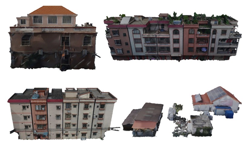
We propose a robust cloth simulation method for filtering ground primitives from photo-realistic 3D meshes. The method can accurately decompose the realistic 3D meshes into the 3D ground and non-ground 3D model, and it is robust for different landscapes and is not impacted by vertex density and noise.
Dayu Yu, Lianlian He, Fan Ye, Liangcun Jiang, Chenxiao Zhang, Zhe Fang & Zheheng LiangInternational Journal of Applied Earth Observation and Geoinformation, 111: 102820, 2022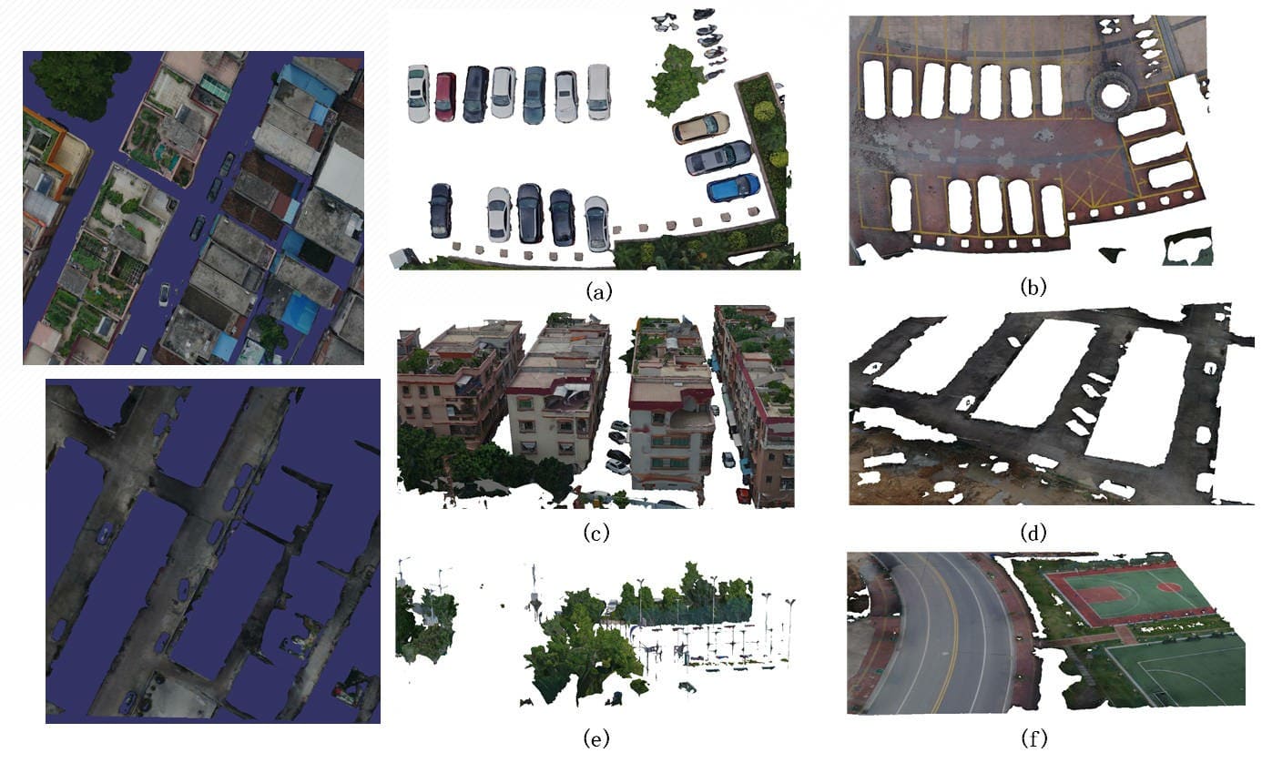
Building upon the physical properties of tailings flow, we developed a VGE platform for dam failure disaster evolution simulation, which can simulate and predicts the route and disaster-causing range of tailings after a failure, and visualize the results in a three-dimensional, dynamic and interactive manner.
Dayu Yu, Liyu Tang, Fan Ye, & Chongcheng ChenInternational Journal of Digital Earth, 14(9): 1194-1212, 2021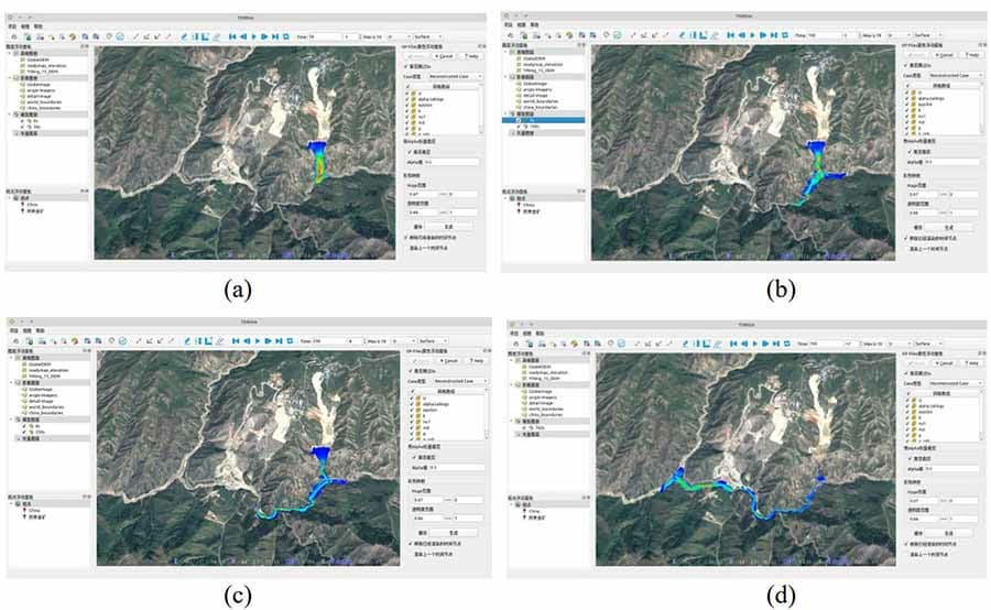
Get in Touch
Please do not hesitate to reach out if you have an interesting idea for collaboration, have some research opportunity to share, or would like to discuss some ideas. I have a broad interest in all things 3D GIS, not limited to, 3D City Modelling, 3D Geographic Information Services, Virtualized Geographical Environment, 3D Visualization, and 3D Spatial Data Infrastructure. Looking forward to connecting and hearing from you!